Oh how we wish for snow that as soon as a model shows a forecast snow storm, we get excited and throw reason out the window. A case in point was demonstrated so well on 02 December 2011 in Norman, OK. What was a supposed to be a shearing positively tilted upper-level trough leaving us with no consideration of a second, wintery act, became suddenly a deeper carved out trough with a downstream ridge (figure 1). That downstream ridge upstream trough would've resurrected the low-level jet back to our southwest giving us a big snow storm as that moisture-laden jet surged over a dome of arctic low-level air draped over us. The result was a global ensemble mean six hour probability of .25" of precipitation forecast ending 18 z 05 December going from nothing to 60% (figure 2). Deep cold air meant we'd get the majority of that as sleet or snow. And since this was an ensemble mean, that meant quite a few ensemble members were going for 1" storm total liquid equivalent with a few members of the short-range ensemble dropping a full 2" of liquid equivalent precipitation on us, most of it frozen (figures 3-4).
 |
| Figure 1. Global Ensemble Forecasting System (GEFS) forecast valid for 05 December 2011 - 18 UTC. The left (right) two panels was from the 18 UTC forecast on 01 (02) December. The top two panels represent spaghetti plots of selected 500 mb heights. The bottom two panels represent the ensemble mean 500 mb heights with standardized anomalies shaded. |
 |
| Figure 2. The same as figure 1 except the top two panels represent the probability of 0.25" or greater liquid QPF ending at 18 UTC of the forecasted time. The bottom two panels represent the spaghetti plots of the six hour 0.25"QPF. |
 |
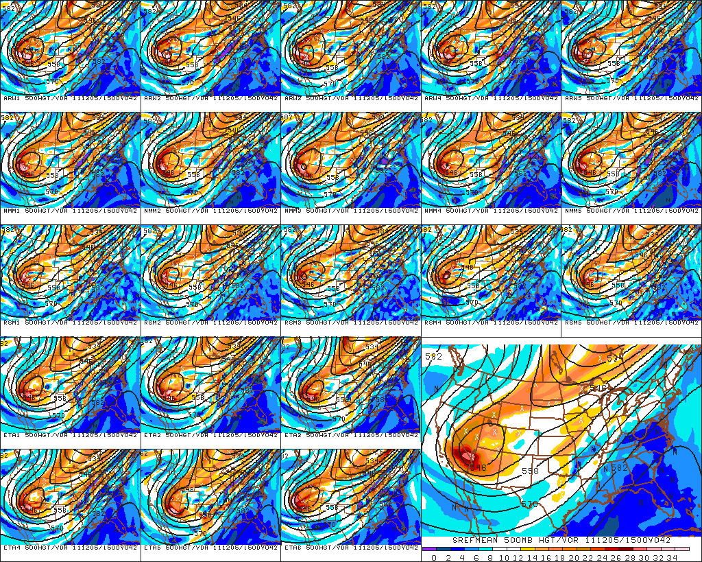
| Figure 3. SREF ensemble meteogram forecast made 02 December 2011 - 03 UTC for Norman, OK visualized in BUFKIT. The green (blue) traces represent accumulation of liquid QPF in inches in liquid (frozen) form (see white labels on the right). The white traces represent the snow accumulation in inches using the same white labels on the right. The red traces represent 2m temperature in F. |
 |
| Figure 4. Same as figure 3 except for the forecast made 02 December 2011 - 15 UTC. |
Needless to say, the impact of this bullish turn of model projections instigated a rush to the Hazardous Weather Testbed by all sorts of National Weather Center members (figure 5). That included me of course. We all wanted to see the monster snowstorm play out on the various model runs displayed on the big 60" monitors.
 |
| Figure 5. A scene from the Hazardous Weather Testbed from 02 December 2011. |
Was there reason amongst any of us or did we throw logic out the window and replace it with weather weenie ghoulish masochism? Well, a few of us wondered how we'd get that new short-wave trough from Alaska to Northwest Territories and all the way down into Arizona in perfect synchrony to recharge the long wave trough in just the right position. Some others were more interested in whether we'd get 3" of sleet or 18" of snow. Luckily the important folks next door at the NWS office weren't too swayed by these juicy predictions. They did respond with a special weather statement highlighting the potential for accumulating snow after Sunday.
MEANWHILE...ANOTHER STORM SYSTEM OVER THE SOUTHWESTERN
STATES WILL BEGIN TO MOVE EAST BY SUNDAY NIGHT.  PRECIPITATION...
MAINLY IN THE FORM OF SNOW...MAY BEGIN TO FALL ACROSS PARTS OF
WESTERN OKLAHOMA AND WESTERN NORTH TEXAS AS EARLY AS SUNDAY
NIGHT.  ON MONDAY...SNOW MAY SPREAD EAST INTO CENTRAL AND SOUTHERN
PARTS OF OKLAHOMA.  AT THIS TIME...THE BEST OPPORTUNITY FOR
ACCUMULATING SNOWFALL APPEARS TO BE SOUTH OF A LINE FROM TULSA
TO OKLAHOMA CITY TO LAWTON AND VERNON...TEXAS.  IT IS TOO EARLY TO
PREDICT EXACT AMOUNTS OF SNOW AND THERE IS STILL THE POSSIBILITY
THAT LITTLE OR NO SNOW WILL FALL.
The bullish snow forecasts continued for another two SREF ensemble runs and then the disappointment began. Starting with the 03 December 03 UTC run, most of the members of the ensemble started to back away from the prodigious snow totals. By the late morning on the 3rd, the runs showed almost nothing. The NWS office, acting with momentum, kept the wording in for potential snow, forecasting 3-6" in snow bands from their 5 am outlook, and then started to back off by 11 am with wording as below:
AT THIS TIME...THE BEST OPPORTUNITY FOR ACCUMULATING SNOWFALL
APPEARS TO EXTEND FROM NEAR HOLLIS... VERNON AND WICHITA FALLS AREAS
NORTHEAST TOWARD HOBART... LAWTON... DUNCAN...OKLAHOMA CITY...AND
STILLWATER. WIDESPREAD LIGHT ACCUMULATIONS LESS THAN TWO INCHES ARE
EXPECTED...AND THESE ACCUMULATIONS WOULD BE MAINLY CONFINED TO
GRASSY SURFACES...CARS... AND TREES.
Well, the model runs kept going drier and drier to the point where nothing was forecast by 36 hours in advance of the supposed event. To see an animation of SREF dmodel/dt, check out the 500 mb (figure 6), surface 6 hour precipitation plots (figure 7) from the
Penn State e-wall site. There's a few missing runs and panels but the point should be made pretty clear about the phantom snow runs starting early morning on the 2nd and then ending 24 hours later.
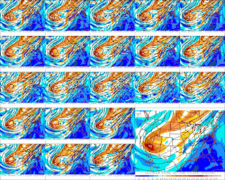 |
| Figure 6. A loop of SREF individual ensemble members (small panels) and the mean (large panel) 500 mb height and absolute vorticity (shaded) valid for 05 December 2011 - 15 UTC. The loop began at initialization time of 01 December 2011 - 21 UTC and ended 03 December 2011 - 21 UTC. Some six hourly initialization times were missing. |
 |
| Figure 7. Similar to figure 6 except for sea-level pressure, 1000-500 mb thickness and 3 hour precipitation in mm. |
Perhaps this animation below better shows the onset and demise of our wishes for a big snow storm using dmodel/dt of our time trace SREF forecast snow accumulation courtesy of BUFKIT (figure 8). The white traces represent total snow accumulations by each run where time increases to the left. The animation starts out with only a couple members forecast a few inches by 15 UTC on 05 December (Monday), then a sudden surge in model aggressiveness with a few members going well above 8" and then the disappointing demise of the potential at the end of the loop (that's 15 UTC 03 December).
 |
| Figure 8. Similar to figure 3 except that this is a loop of meteograms starting from 01 December 2011 - 21 UTC and ending 03 December 2011 - 21 UTC. |
My takeaway from this event was that inter run differences can still exceed the range of possibilities within each ensemble run. I may be too harsh because technically there was an ensemble member during the most bullish SREF that had little snow but no runs during the Friday late morning runs were forecasting a totally dry Monday. Two runs later Friday night and we see a bunch of dry runs.
So, like the NWS, it's preferable to play the role of being a 'big ship' and contain our collective excitement. Luckily no watches or warnings were issued because the forecasters were not sold yet on an event that would overwhelm the relatively warm ground with loads of snow and ice. Still, it is okay to dream a little with some help from an overly aggressive model run. After all, sometimes we get an event that exceeds its expectations.


No comments:
Post a Comment